Main image: Rhossili Bay Beach, Wales. Credit: ©Johnny Greig/Getty Images
This is an exclusive extract from Lonely Planet’s Epic Runs Of The World, 50 first-hand accounts of the races and routes that should be on every runner’s bucket list. Here, writer Sarah Stirling guides us through a 13-mile (21km) loop along the Pembrokeshire Coast Path – and recommends where to get ice cream afterwards.
A Portal To The Past In Pembrokeshire
Wales’ westernmost point sits in one of Britain’s most beautiful national parks. This world-class trail run is a race through time as it passes stunning ancient monuments.

The southwest tip of Wales is a geologist’s playground where rock scars and layered cliffs leave striking clues about our past. Some of this rock dates right back to the Precambrian era, before multi-cellular life first emerged. With its remnants of ancient civilisations littering the coastline, this edge of Wales is also heaven for history lovers, as Britain’s earliest architects had a penchant for north Pembrokeshire rock (Stonehenge was built from bluestones found in nearby hills). And yet to my mind this stretch of cliffs and beaches holds something even more exciting than all of that: one of the most beautiful trail runs in all of Britain.
Over the years I’ve compiled a fat file of runs in Wales, and this 13-miler (21km) skirting the country’s westernmost peninsula remains my favourite. It begins off-road along the Pembrokeshire Coast Path and completes the loop on country lanes. Indeed, the in-your-face history and geological beauty are inspiring, but the natural flow, isolation and ruggedness make it feel as though it was built for early morning half-marathons.
Immediately upon setting off, I feel the freedom and exhilaration of the path. It’s rocky in places but rarely awkward enough to demand my gaze. The rock all around me, however, is hard to ignore. Colourful cliffs rise around me, some of the faces a deep purple, others a shade of rose. Red-and-white striped pebbles on the beach resemble boiled sweets. The cliffs jutting into the sea seem primeval and alive. The path ahead rolls into the distance, bursting with wildflowers in pink, blue and gold.
Today – and every time I run here – there seems to be a deeply spiritual vibe. But it’s only if you really tune into the environment that you begin to trip over the ghosts of Welsh mythology. The area has been so lightly touched by modern man that you’ll pass by forgotten Stone Age monuments, crumbling Bronze Age roundhouses, the ramparts of an Iron Age fort, Dark Age chapel ruins and even a hidden medieval cathedral. But it’s not as simple as scanning the landscape as you jog. You have to run mindfully, and even explore off the path a little to spot the ruins among the rocks and earth that have begun to hide them.
Most importantly, there is hardly anyone else here. In fact, it feels as though hardly anyone has ever been here. Thankfully, the ribbons of frustrating country lanes, slow tractors and sheep between Pembrokeshire and the rest of the world defend this corner from all but the determined few. Even if the crowds do discover it someday, I take solace in the fact that it will always enjoy some level of protection, thanks to its status as a national park. It was in fact one of Britain’s very first national parks – designated way back in 1952 – and remains the only coastal one.
I power along the clifftop to a promontory at the end of Caerfai Bay, then pause to look back. Opposite is another piece of land jutting out, connected by a narrow natural bridge. I can just make out the banks and ditches of the Iron Age fort here, which is slowly being dismantled by the sea. Legend has it King Arthur roamed these parts during this era, fighting raiding tribes from overseas. What emerged is the idea of Wales itself. The Anglo-Saxons who began to dominate England called the Celts ‘Wealhs’ – foreigners.
Just a half-mile in and my feet start to fly as I settle into the flow of the path. I leap over a few tendrils of scratchy gorse bushes to reach the stone ruins of St Non’s Chapel. Thought to be one of Wales’ oldest Christian buildings, it is said to mark the birthplace of David, patron saint of Wales. In 1081, William the Conqueror himself made a pilgrimage to the monastery. Not long after, work on St Davids Cathedral began, on the site of the monastery. Two pilgrimages to this cathedral were then declared equal to one made to Rome.
I trot carefully downhill towards a deep inlet with a tiny picturesque 12th-century stone harbour known as Porthclais. Originally used for importing coal and timber, these days it’s a great place to launch a kayak. In fact, it’s here that I feel as though I leave the ancient world behind and step into this park’s future, as adventurous daytrippers are launching colourful boats into the bay and I can hear the jangle of rock climbers placing gear into the cliffs. As I carry on, the chatter of swimmers rises up from Porthlysgi Bay; soon I will see surfers riding the waves in Whitesands Bay.

A puffin peeks out of its burrow at The Wick on Skomer. Credit: LP Staff Collection
Reaching Pen Dal-aderyn, the westernmost tip of mainland Wales, I sit down to bite into a sandwich. This is a good place to spot seals and dolphins. I can see a boat in the water, taking tourists out for a closer look at the sealife and to spot puffins waddling on the nearby islands. Thinking about what a peaceful natural playground this place is today, I can’t help but wonder what the ghosts of the Pembrokeshire coast make of all the brightly coloured Gore-Tex and Lycra.
The next stretch is a clifftop blast that rewards you with views of Whitesand Bay’s vast beach. Beyond the beach, the rocky top of Carn Llidi pokes up through the hill’s green flanks. On its hillside stands the oldest monuments on this run: a lichen-covered 20ft slab, hefted into place in the late Stone Age, around 3000 BC, to mark a tomb. Nearby are several low, circular stone walls – once Bronze Age roundhouses – along with ancient animal enclosures. I like to veer off-trail to explore these, somehow drawn to enter the gaps that were doors and gateways, even though the tumbled walls are low enough to step over.
Heading south on country lanes, there’s no avoiding civilisation as I enter the village of St Davids, which, because of the aforementioned cathedral, claims to be Britain’s smallest ‘city’. It may be small but this village is well aware of its natural assets. From regular beach clean-ups to carbon neutrality, St Davids is known for its progressive thinking when it comes to saving the environment. This forward-thinking community is hell-bent on preserving this coastline, allowing the Stone Age men, warriors, saints, kings and medieval pilgrims haunting the clifftops to continue their business unbothered.
Sarah Stirling
Nature’s Call
Between April and September, the islands around the Pembrokeshire coastline become loud, noisy cities of sex-mad birds in the height of mating season. The best island to visit during the wildlife love-fest is Skomer, home to the largest Atlantic puffin colony in southern Britain. There are 21,000 of them, all remarkably unbothered by tourists so watch your step. There are also 23,000 guillemots and 7,000 razorbills!
Orientation
Start/End St Davids
Distance 13 miles (21km)
Getting there St Davids is 16 miles (26km) from the nearest train station, which is in Haverfordwest.
When to go Spring and summer are the seasons for spectacular wildflower shows. Autumn and winter promise big surf and the ultimate peace and quiet.
Where to stay You’ll get a warm Celtic welcome at the well-kept Ty Boia B&B (www.ty-boia.co.uk). Or there’s camping at Caerfai Farm (www.caerfaifarm.co.uk).
More info www.pembrokeshirecoast.wales
Things to know Be sure to top off your run with a Celtic Crunch ice cream at Gianni’s.
More Like This: Wild Welsh Headlands
The Llyn Peninsula

The coastal village of Aberdaron in North Wales. Credit: ©David Toase/Getty Images
Llŷn Peninsula extends into the sea west of Snowdonia. It is a particularly rural, quaint and quiet spot at the very fingertip of the peninsula, where a huge carpet of white sand is laid out in front of the village of Aberdaron. Head west, following the coastal path round to Pen y Cil, the southwestern point of the headland, looking out for dolphins and seals. Continue north to Braich y Pwll, the westernmost point on the North Walian mainland, admiring Bardsey Island with its 19th-century lighthouse (the tallest square-towered one in the UK), and imagining medieval pilgrims rowing across to visit the 1500-year-old monastery. Archaeological finds prove that the island has been inhabited for at least 4000 years. Now either retrace your steps or follow the minor road back.
Start/End Aberdaron
Distance 6 miles (9.6km)
More info www.llyn.info
Holy Island
Just beyond the west coast of Anglesey lies a much smaller island, connected by a bridge. The quartzite rocks of its highest summit, Holyhead Mountain (722ft; 220m), can be seen from miles around; in summer the lower slopes are cushioned with purple heather. Around these lower slopes, and elsewhere on the island, there are a number of standing stones and burial chambers, hence the name Holy Island. From South Stack car park, follow the coast path up past the photogenic lighthouse, which clings to an offshore islet. In spring, guillemots and puffins breed and chatter noisily on these cliffs, and you can see choughs all year round. Follow the path round to North Stack before scrambling up to the summit of Holyhead Mountain for more views. Descend west to return to the car park.
Start/End South Stack
Distance 4.5 miles (7.2km)
More info www.visitanglesey.co.uk
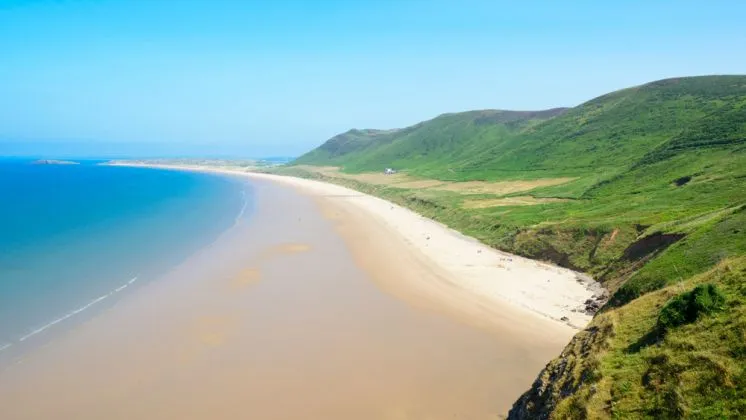
The Gower Peninsula
This tongue of land jutting into the sea just west of Swansea was designated an ‘Area of Outstanding Natural Beauty’ back in 1956, and it hasn’t changed much since. Right at the tip lies a 3-mile (4.8km) strip of pure butterscotch beach with the spine of Rhossili Down behind it. Run along the beach, then follow the path up and along the top of the low cliffs that mark the northern end of the Gower Peninsula. Continue round Foxhole Point, before picking up footpaths and slogging up and along the dunes behind the beach to reach The Beacon (633ft; 193m). There are spectacular views down to the village of Rhossili and Worms Head beyond. The latter is a narrow tail of land that dips into the sea and then rises again to a little headland. Scramble down steeply to return to the car park.
Start/End Rhossili
Distance 9.5 miles (15km)
More info www.explore-gower.co.uk
Reproduced with permission from Lonely Planet © 2019

